April 2-8, 2002
Introduction
This was an intentionally unplanned, serindipidous trip. Our only
commitment upon leaving was a three-day
reservation at the Best Western in Lone Pine, in the middle of the
Owens Valley. We had some ideas of other
things to visit, but we had no obligations to each other or anyone
else.
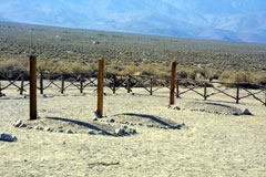
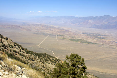
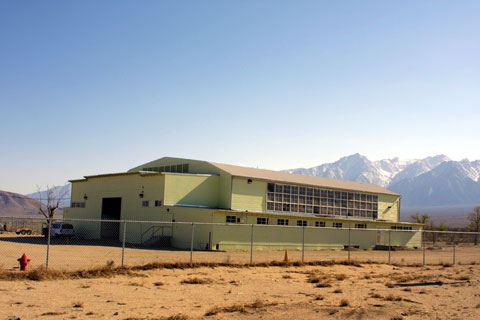
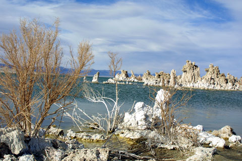
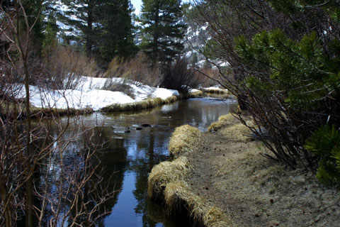
| The Owens Valley is to the west of Death Valley, which has become a favorite haunt of ours over recent years. All I knew about Owens Valley was from the bits and pieces I remembered from the video series, Cadillac Desert. This PBS series chronicled the way in which LA stole the water from a fertile farmland and turned it into a desert. My only direct experience of all this was from driving along the side of Owens Lake on one trip back from Death Valley. Here's what the "Lake" looks like today. It is now a salt flat, with some patches of water. | |
Tuesday - April 2th
| We left Anaheim around 1145, a bit later than planned, but we intended
this to be a relaxed, flexible trip. We headed up Route 15 toward
Las Vegas, exited to the West at Victorville, a route we've taken into
Death Valley from its West side.
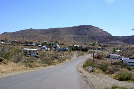
Our first stop was the "living ghost town" of Randsburg, shown below. |
 |

 |
| We drove along the west side of Owens Lake and arrived shortly thereafter at Lone Pine. The Best Western was good for our purposes, and we stayed in the Hopalong Cassidy room. (More about that tomorrow.) |
 |
 |
Wednesday - April 3, 2002
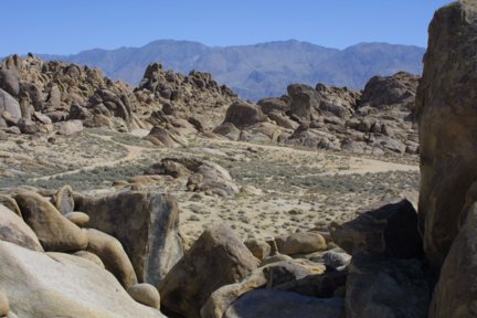
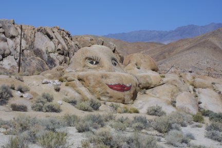
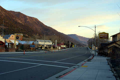
| It turns out that one of Lone Pine's main claims to fame is as a movie set. The surrounding deserts, hills, and mountains have hosted virtually every Grade B cowboy movie ever made, as well as "High Sierra" with Humphrey Bogart, "Gunga Din," not to mention "The Khyber Rifles," and the list goes on and on. | We spent much of Wednesday morning driving around the movie sets. Even if we couldn't identify specific locations for specific movies (the guide books will do that if you care enough), we loved the area in general. Here's a sampling of what we saw in the Alabama Hills. |
 |
 |
 |
 |
If you look closely, you can see a tiny Sheila under the right side
of the boulder in the bottom-left photo. The bottom-right photo captures
some of the amazing natural rock formations in this area. 8-)
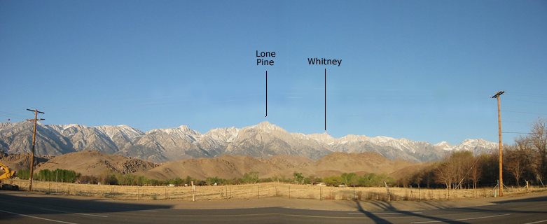
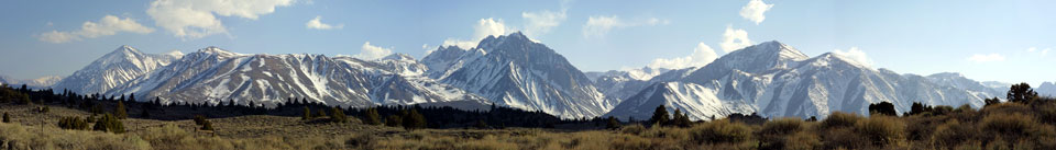
The upper-right photo reminds you that we are along the east side of the Sierra Nevada mountain range. The highest peak, Mt. Whitney, is the highest mountain in the lower 48 states. (Eat your heart out, Rocky Mountains.)
Here's Mt. Whitney, not to mention our own Mt. Lone Pine. If Whitney doesn't look all that impressive in this picture, it's because it is so far beyond the others.
This spliced-together composite photo, by the way, was taken from our motel. Not a bad view, especially once you've removed the telephone and power lines. The bump in the center of the road is an artifact of the splicing, not the result of an earthquake. In 1872, however, a 1905-San-Francisco-sized earthquake raised the floor of the valley something like 21 feet, killing a couple dozen people and pretty much destroying the town. Now you know how those mountains got there in the first place.
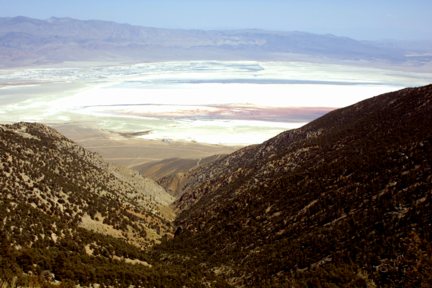
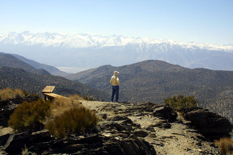
Some years ago, Disney had an idea that it would build a resort high
up in the mountains. It got so far as to build a switchback road
to the summit near Lone Pine, and then their resort plans were evidently
denied. The road remained, however. My opening photo of Owens
Lake was taken from this road. Wednesday afternoon, we decided to
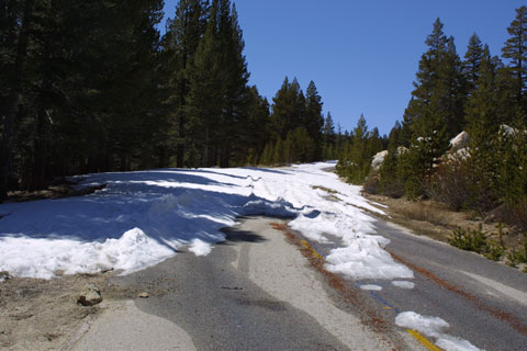
climb the mountains, despite the road being closed.
 |
 |
We made it up all the switchbacks, clinging to the side of the mountain,
with no guardrails, missing all the rocks. Four-wheel drive got us
through the first snowdrift, but we got stuck in the second. I wasn't
sure we'd be able to get back out, but I was motivated by the advanced
warning that it would cost an arm and a leg to get a tow truck up
there (assuming we could reach them) and that CHPs would be waiting for
us when we got down. We'd been headed for Horseshoe Meadow, where
there is supposed to be a fabulous view of Mt. Whitney. The view
wasn't too bad where we stopped for our picnic lunch, however. You
can see the road we were on in the picture. We got to around the
last part of the road you can see.
 |
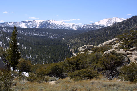 |
The view coming down wasn't too bad either. You can see part of
the road in the first picture. Though it doesn't show up well in
the second photo, that's Lone Pine in the distance. (Hey, I can see
my house from here!)
 |
 |
|
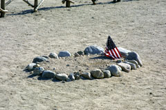
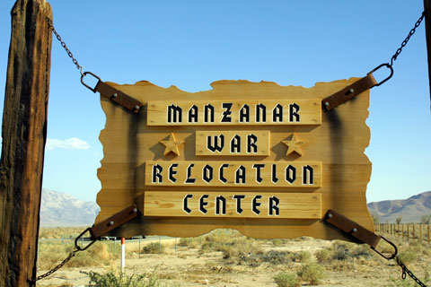
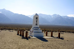
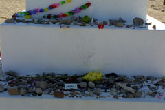
About 10-15 miles north of Lone Pine is the site of the Manzanar War Relocation Center, where Executive Order 9066 interred some 10,000 Japanese-Americans for the duration of World War II. Our friends, Tom and Mary Kitagawa lived there, though Tom left shortly to join the 442 Regiment, made up exclusively of Japanese-Americans and the most highly decorated American unit in the war. Manzanar was one of ten such camps, housing a total of 110,000 whose only crime was to have been of Japanese ancestry. Hawaii, with the highest concentration of Japanese-Americans and the only state actually attacked in the war didn't honor the Executive Order. Only Japanese language instructors and Shinto priests were sent to the camps. My first sociology chairman in Hawaii, Doug Yamamura, said that the day after Pearl Harbor, someone from civil defense apologetically confiscated Doug's shotgun and short-wave radio. The next day, the same official gave Doug a machine gun, a jeep, and a portion of shoreline to guard. Today, the only building standing at Manzanar is the auditorium. There is also a small graveyard and a memorial obelisk, the latter covered with mementos left to honor those who lived and died here. As the plaque at the gate indicates, "May the injustices and humiliation suffered here as a result of hysteria, racism and economic exploitation never emerge again." |
 |
 |
|
Thursday, April 4, 2002
Some of the places we thought might be interesting were quite a bit
north of Lone Pine, so we cancelled our third night there and made reservations
for a couple of nights at Lee Vining, a town perched on a bluff overlooking
Mono Lake and reputely housing only 398 people. As we were to later
discover, it is also known as "The Gateway to Yosemite." Getting
to Lee Vining was a string of adventures.
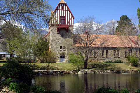 |
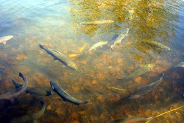
We began with a fish hatchery, It was billed as the most beautiful
fish hatchery in the world, and we found no reason to quibble with that.
The pond was packed with huge trout.
|
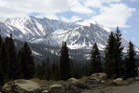
The drive north took us along the eastern side of the Sierras. Both Sheila and I developed a deep sense of awe and respect for these majestic mountains. (Hey, I know "majestic" is a little cliche-ed, but these guys left me at a loss for words--unused words, that is.)
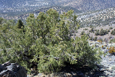
Our next stop on the drive north was a lengthy excursion into the hills
in search of the Ancient Bristlecone pines, the oldest living things on
the planet: as much as 4,000 years old. They are not that big, unlike
the towering sequoias, which we previously believed to be the oldest trees.
The end of the road was closed but we got a good view from the end of the
passable road and we saw some trees we agreed to believe were bristlecone
pines.
 |
 |
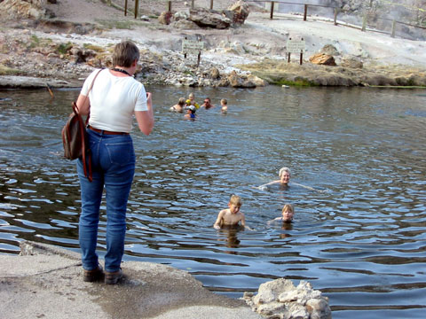
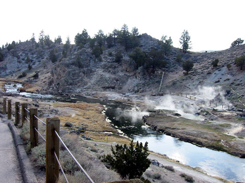
One adventure we had been curious about was the Hot Creek--a mixture
of chilly runoff from the snow pack and thermal leaks. Some parts
of the creek carried the promise of hypothermia, while other spots were
hot enough to have killed 14 people so far by par-boling. The Park
Service says you can't swim there, though they provide changing rooms so
you won't be adding nudity to your list of offenses. You should be
able to see Sheila in the first picture. The swimming hole is to
the left in the second one.
 |
 |
|
Feeling a bit salty and oily, we finally arrived at Lee Vining and had our first experience of Mono Lake. For all we had heard about it, it was much more impressive than we had imagined, and we became all the more politically aroused about it. |
 |
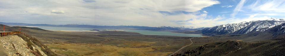
This photo is taken from the north and, to coin another clever phrase,
can't do justice to the real thing. Lee Vining is a little bit around
the corner of the right side of the lake in the photo. The vast Mono
Basin, between our lookout and the lake was largely covered with water
prior to 1941, when Los Angelos found it could not continue to overpopulate
the southwest without more water. Having turned the Owens Valley
farmlands into a desert, LA managed to procure water rights to four of
the six rivers that feed into Mono Lake and make up for the continuing
water loss due to evaporation. (There are no rivers running out of
the lake.) Today, Mono Lake is two-and-a-half times as salty as the
Pacific Ocean.
Friday - April 5, 2002
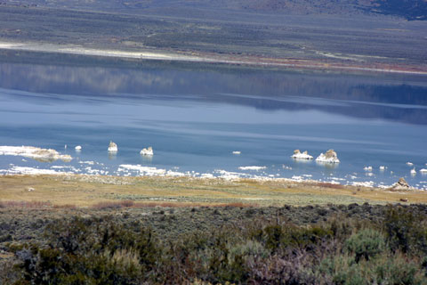
Local and statewide political action to Save Mono Lake (we recalled the bumper stickers, at least) have brought some relief, and the lake is higher today than in recent years. Still, it is a threatened ecosystem, and a significant one. Some 80% of the seagulls in California spend time here, for example.
One of the most striking features of Mono Lake consists of the stalagmite-like
tufas, poking out of the water, mostly on the western and southern shores.
With the LA-induced water loss, many of these are now completely out of
the water. We explored the tufas on Friday.
 |
 |
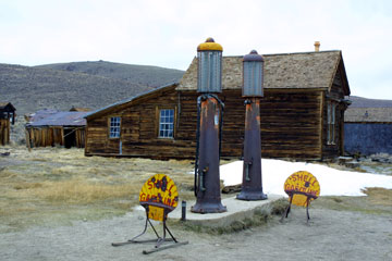
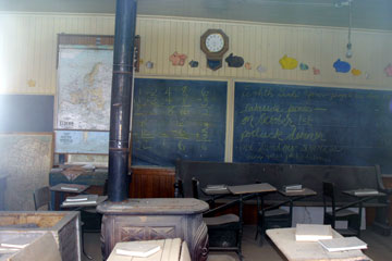
One of the strangest adventures on our trip was our visit to Bodie, billed as "the world's largest ghost town." A prosperous gold rush town of 10,000, Bodie had a reputation of being geographically isolated, suffering rotten weather, and populated by some of the meanest people around. It was also, ironically, one of the first cities in the world to be fully electrified. As the gold.com bubble burst, Bodie fell on increasingly hard times, and the population dwindled. Then, a devasting fire in 1932, drove the rest of the residents out. Today, it is preserved by the Park Service, and you can peek in the windows and see how hastily people left town. There are still dishes on tables, clothes hanging on hooks, arithmetic on the school blackboards. It's like Pompei without the lava and ash. Here's a sampling of Bodie views.

 |
 |
 |
 |
Saturday - April 6, 2002
When we left Lone Pine, we made reservations to return there on Saturday,
breaking up the return to Anaheim. That also gave us the opportunity
for a couple of additional adventures between Lee Vining and Lone Pine.
The first, at Rock Creek, up into the mountains from Tom's Place (surely
you've heard of Tom's Place) was truly serene.
 |
 |
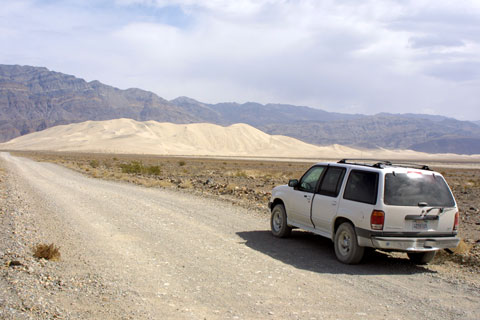
Two hours later, we had driven up over the mountain range separating
Owens Valley from Death Valley and had entered the northen end of the latter.
Though Sheila and I have a love affair with Death Valley, this was new
territory for us, so desolate that we both felt a little nervous about
it. Any nasty things we had said about the Ford Motor Company and
the gas-huzzling habits of Explorers were now trumped by the steady stream
of prayers we said on behalf of our brave little vehicle. Thanks
to the apparent power of prayer, we were soon (well, two hours soon,
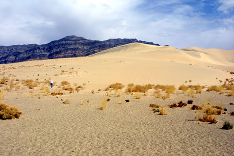
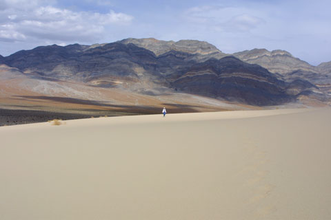
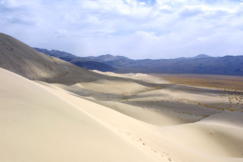
like ninety years young), face to face with the Eureka Dunes.
Seven hundred feet high, they are the tallest sand dunes in North America.
The guide book says it takes about 3 hours to hike to the highestmost point
and back, and that was confirmed by some hikers we met. We demurred.
We did, however, pause to play in America's biggest sand box.
 |
 |
 |
 |
| By the time we made it back to Best Western in Lone Pine, we felt our
trip was complete and certainly worthwhile. As though to cap it for
us, the sun peeked between clouds and mountains to say good-bye.
We'll be back. |
 |